Here's where you can learn a little Ontario history
The Grand Portage
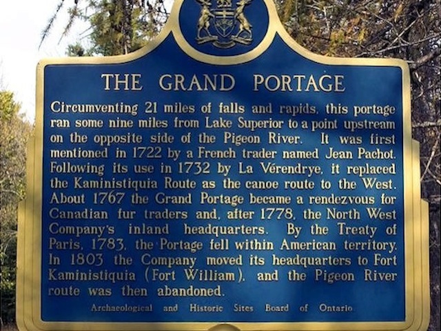
Photo by contributor Dave Fernie - October, 2005
Plaque Location
The District of Thunder Bay
The Municipality of Neebing
In Middle Falls Provincial Park across the river from the site of the
former portage, Highways 593 and 61 - southwest of Thunder Bay
(coordinates unknown)
Plaque Text
Circumventing 33 km of falls and rapids, this portage ran some 14 km from Lake Superior to a point upstream on the opposite side of the Pigeon River. It was first mentioned in 1722 by a French trader named Jean Pachot. Following its use in 1732 by La Vérendrye, it replaced the Kaministiquia Route as the canoe route to the West. About 1767 the Grand Portage became a rendezvous for Canadian fur traders and, after 1778, the North West Company's inland headquarters. By the Treaty of Paris, 1783, the Portage fell within American territory. In 1803, the Company moved its headquarters to Fort Kaministiquia (Fort William), and the Pigeon River route was then abandoned.
Related Ontario plaque pages
Grand Portage
Sieur de La Vérendrye 1685-1749
Great Dog Portage
North West Company
Fort Kaministiquia 1717
More
Information
More
Waterways
Here are the comments for this page.
(none yet)
Here's where you can write a comment for this page.
Note: If you wish to ask me a question, please use the email link in the menu.
Note: Comments are moderated. Yours will appear on this page within 24 hours
(usually much sooner).