Discover Ontario's history as told through its plaques
2004 - Now in our 15th Year - 2019
To find out all about me, you can visit the Home Page
Looking at this page on a smartphone?
For best viewing, hold your phone
in Landscape mode (Horizontal)
New Credit Indian Reserve and Mission
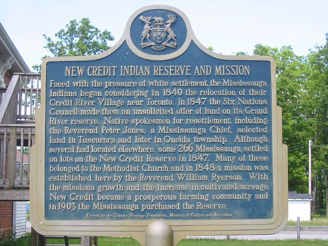
Photo by Alan L Brown - Posted June, 2004
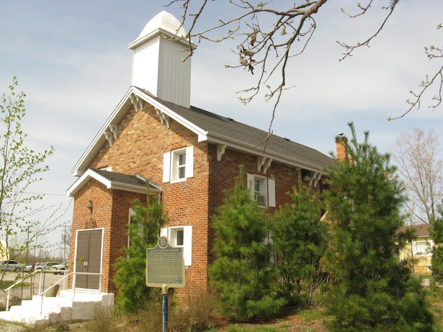
Photo by contributor Wayne Adam - Posted April, 2010
Plaque Location
The County of Brant
Six Nations of the Grand River
In front of the New Credit Council House
at the end of Core Area Way
which runs north from Mississauga Road
just east of New Credit Road
Coordinates: N 42 59.991 W 80 05.672 |
 |
Plaque Text
Faced with the pressure of white settlement, the Mississauga Indians began considering in 1840 the relocation of their Credit River Village near Toronto. In 1847 the Six Nations Council made them an unsolicited offer of land on its Grand River reserve. Native spokesmen for resettlement, including the Reverend Peter Jones, a Mississauga Chief, selected land in Tuscarora and later in Oneida township. Although several had located elsewhere, some 266 Mississauga settled on lots of the New Credit Reserve in 1847. Many of these belonged to the Methodist Church and in 1848 a mission was established here by the Reverend William Ryerson. With the mission's growth and the increase in cultivated acreage, New Credit became a prosperous farming community and in 1903 the Mississauga purchased the Reserve.
Another plaque at this location
Reverend Peter Jones (1802-1856)
More
Information
More
First Nations
Other Plaques in Six Nations of the Grand River
Ahyouwaeghs * John Brant 1794-1832
Chiefswood
E. Pauline Johnson 1861-1913
The Six Nations
Thayendanega (Joseph Brant) 1742-1807
Tom Longboat 1886-1949