Ontario's Historical Plaques
at ontarioplaques.com
Learn a little Ontario history as told through its plaques
Lost Villages of the St. Lawrence
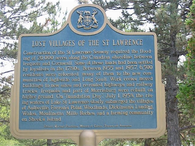
Photo by Alan L Brown - Posted June, 2005
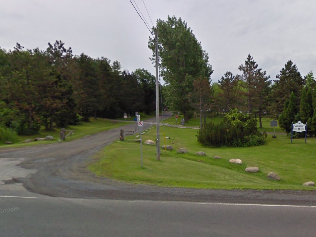
Photo from Google Street View ©2010 Google - Posted November, 2010
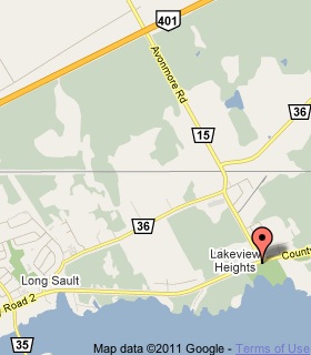
Plaque Location
The United Counties of Stormont, Dundas and Glengarry
The Township of South Stormont
On the south side of Road 2 at the south end of Road 15
Coordinates: N 45 01.928 W 74 51.472 |
 |
Plaque Text
Construction of the St. Lawrence Seaway required the flooding of 8000 ha along the Canadian shoreline between Iroquois and Cornwall. Some of these lands had been settled by loyalists in the 1780s. Between 1955 and 1957, 6,500 residents were relocated many of them to the new communities of Ingleside and Long Sault. Work crews moved buildings to new sites and re-routed highways and railway tracks. Iroquois and part of Morrisburg were rebuilt on higher ground. On "Inundation Day", July 1, 1958, the rising waters of Lake St. Lawrence slowly submerged the villages of Aultsville, Farran's Point, Woodlands, Dickinson's Landing, Wales, Moulinette, Mille Roches, and a farming community on Sheek's Island.
Related Ontario plaques
The Construction of the St. Lawrence Seaway
United Empire Loyalists
More
Information
More
Canals
Here are the visitors' comments for this page.
Posted February 23, 2011
Eight years after the flood, in 1966, a provincial plaque to the Lost Villages was unveiled in a ceremony at which the oldest citizen from each former village participated. When the plaque's text was read aloud, Fran Laflamme, a local grade school teacher, was horrified. Her beloved town of Wales had been omitted from the marker. "With Fran's order, the plaque was removed and a new one prepared," says Jim Brownell, who attended that day, and is now the MPP for the area. Wales indeed appears on the replacement plaque, above. Fran's passion led her to found the Lost Villages Historical Society and Museum, and she was its first president. The community to which she dedicated so much thanked her by naming the road at the museum 'Fran Laflamme Drive'. Though sick, she attended the dedication ceremony in the spring of 2000. Weeks later, on June 29, she died. -Wayne
Posted February 11, 2011
Before ever seeing this plaque, I was moved by reading its text in a booklet, and became fascinated by the intentional flooding of some of Ontario's most historic lands. It became the subject of my senior thesis in college, leading to several trips to the area. On one, I snorkeled over the foundations of buildings submerged for decades. I felt privileged to speak with those who had lived in the Lost Villages, and some, like Fran Laflamme, who worked to preserve their memory through the Lost Villages Historical Society (see its website). While many residents were persuaded to abandon their homes in favor of modern bungalows, the Society maintains a few buildings moved from the villages before the flood. Despite destroying pioneer sites, the Seaway project left a historical legacy by creating Upper Canada Village, comprised of significant buildings collected from the Lost Villages. These drowned places haunt me still. Along a forgotten fringe of Ontario, a great price was paid for progress. Today, the Long Sault Parkway connects a string of island parks---an emerald necklace set amid sapphire waters; places to pause and greet the ghosts below. -Wayne
Here's where you can write a comment for this page.
Note: If you wish to ask me a question, please use the email link in the menu.
Note: Comments are moderated. Yours will appear on this page within 24 hours
(usually much sooner).
Note: As soon as the comment is posted, a link to it will appear on the home page in the section "Here are the 10 latest plaque pages with a new comment added by a visitor to this site."