Here's where you can learn a little Ontario history
Belleville
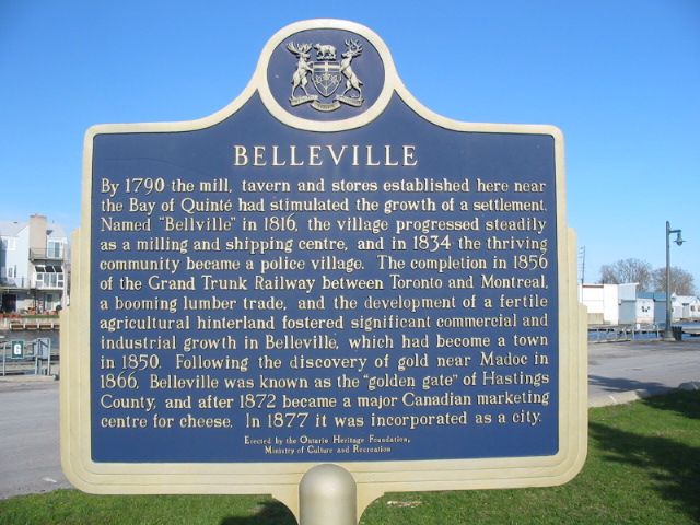
Photo by Alan L Brown - May, 2004
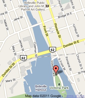
Plaque Location
The County of Hastings
The City of Belleville
On the east side of the park road in Victoria Park
west off South Front Street just south of Dundas Street (Road 2)
Coordinates: N 44 09.498 W 77 22.937 |
 |
Plaque Text
By 1790 the mill, tavern and stores established here near the Bay of Quinté had stimulated the growth of a settlement. Named "Belleville" in 1816, the village progressed steadily as a milling and shipping centre, and in 1834 the thriving community became a police village. The completion in 1856 of the Grand Trunk Railway between Toronto and Montreal, a booming lumber trade, and the development of a fertile agricultural hinterland fostered significant commercial and industrial growth in Belleville, which had became a town in 1850. Following the discovery of gold near Madoc in 1866, Belleville was known as the "golden gate" of Hastings County, and after 1872 became a major Canadian marketing centre for cheese. In 1877 it was incorporated as a city.
More
Information
More
Settlements
Here are the comments for this page.
(none yet)
Here's where you can write a comment for this page.
Note: If you wish to ask me a question, please use the email link in the menu.
Note: Comments are moderated. Yours will appear on this page within 24 hours
(usually much sooner).