Discover Ontario's history as told through its plaques
2004 - Now in our 15th Year - 2019
To find out all about me, you can visit the Home Page
Looking at this page on a smartphone?
For best viewing, hold your phone
in Landscape mode (Horizontal)
The Settlement of Puslinch
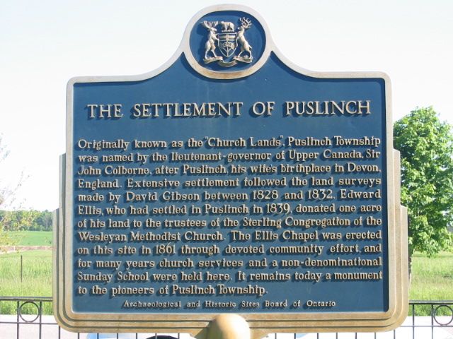
Photo by Alan L Brown - Posted June, 2004
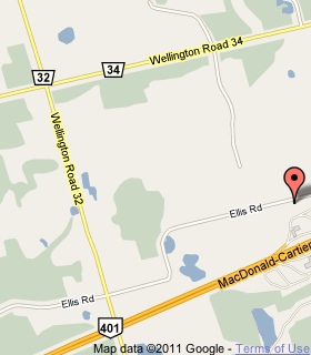
Plaque Location
The County of Wellington
The Township of Puslinch
On Ellis Road, 1.5 km east of Road 32
Coordinates: N 43 26.189 W 80 14.783 |
 |
Plaque Text
Originally known as the "Church Lands", Puslinch Township was named by the lieutenant-governor of Upper Canada, Sir John Colborne, after Puslinch, his wife's birthplace in Devon, England. Extensive settlement followed the land surveys made by David Gibson between 1828 and 1832. Edward Ellis, who had settled in Puslinch in 1839, donated .4 ha of his land to the trustees of the Sterling Congregation of the Wesleyan Methodist Church. The Ellis Chapel was erected on this site in 1861 through devoted community effort, and for many years church services and a non-denominational Sunday School were held here. It remains today a monument to the pioneers of Puslinch Township.
Related Toronto plaque
David Gibson 1804-1864
More
Information
More
Settlements
Here are the visitors' comments for this page.
(none yet)
Here's where you can send me a comment for this page.
Note: Your email address will be posted at the end of your comment so others can respond to you unless you request otherwise.
Note: Comments are moderated. Yours will appear on this page within 24 hours (usually much sooner).
Note: As soon as I have posted your comment, a reply to your email will be sent informing you.
To send me your comment, click .
Thanks
Alan L Brown
Webmaster
Note: If you wish to send me a personal email, click .