Discover Ontario's history as told through its plaques
2004 - Now in our 15th Year - 2019
To find out all about me, you can visit the Home Page
Looking at this page on a smartphone?
For best viewing, hold your phone
in Landscape mode (Horizontal)
The Williamsburg Canals
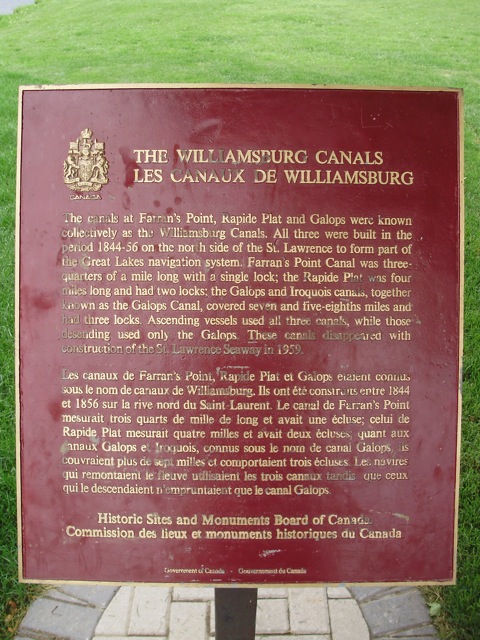
Photo by contributors David & Kellie Clifford - Posted June, 2009
Photo by Richard Turcotte - Posted August, 2015
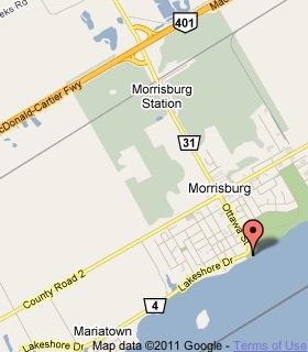
Plaque Location
The United Counties of Stormont, Dundas and Glengarry
The Township of South Dundas
In Morrisburg, at the foot of Ottawa Street (Road 4)
at the water's edge
Coordinates: N 44 53.631 W 75 10.821 |
 |
Plaque Text
The canals at Farran's Point, Rapide Plat and Galops were known collectively as the Williamsburg Canals. All three were built in the period 1844-56 on the north side of the St. Lawrence to form part of the Great Lakes navigation system. Farran's Point Canal was 1.2 km long with a single lock; the Rapide Plat was 6.4 km long and had two locks; the Galops and Iroquois canals, together known as the Galops Canal, covered 12 km and had three locks. Ascending vessels used all three canals, while those descending used only the Galops. These canals disappeared with construction of the St. Lawrence Seaway in 1959.
Related Ontario plaque
The Construction of the St. Lawrence Seaway
More
Information
More
Canals
Here are the visitors' comments for this page.
(none yet)
Here's where you can send me a comment for this page.
Note: Your email address will be posted at the end of your comment so others can respond to you unless you request otherwise.
Note: Comments are moderated. Yours will appear on this page within 24 hours (usually much sooner).
Note: As soon as I have posted your comment, a reply to your email will be sent informing you.
To send me your comment, click .
Thanks
Alan L Brown
Webmaster
Note: If you wish to send me a personal email, click .