Discover Ontario's history as told through its plaques
2004 - Now in our 15th Year - 2019
To find out all about me, you can visit the Home Page
Looking at this page on a smartphone?
For best viewing, hold your phone
in Landscape mode (Horizontal)
The Coldwater Mill 1833
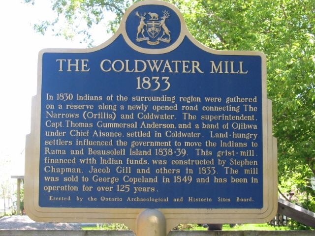
Photo by Alan L Brown - Posted June, 2004
Photo from Google Street View ©2015 Google - Posted February, 2015
Photo by Alan L Brown - Posted June, 2004
Plaque Location
The County of Simcoe
The Township of Severn
In Coldwater, on Mill Street just west of Coldwater Road
1 block south of Sturgeon Bay Road
Coordinates: N 44 42.477 W 79 38.659 |
Plaque Text
In 1830 Indians of the surrounding region were gathered on a reserve along a newly opened road connecting The Narrows (Orillia) and Coldwater. The superintendent, Capt. Thomas Gummersal Anderson and a band of of Ojibwa under Chief Aisance, settled in Coldwater. Land-hungry settlers influenced the government to move the Indians to Rama and Beausoleil Island 1838-39. This grist-mill, financed with Indian funds, was constructed by Stephen Chapman, Jacob Gill and others in 1833. The mill was sold to George Copeland in 1849 and has been in operation for over 125 years.
Related Ontario plaque
Rama Indian Reserve
More
Information
More
Mills
Here are the visitors' comments for this page.
(none yet)
Here's where you can send me a comment for this page.
Note: Your email address will be posted at the end of your comment so others can respond to you unless you request otherwise.
Note: Comments are moderated. Yours will appear on this page within 24 hours (usually much sooner).
Note: As soon as I have posted your comment, a reply to your email will be sent informing you.
To send me your comment, click .
Thanks
Alan L Brown
Webmaster
Note: If you wish to send me a personal email, click .