at ontarioplaques.com
Learn a little Ontario history as told through its plaques
2004 - Now in our 10th Year - 2014
The Black Donald Graphite Mine
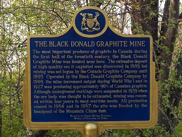
Photo by Alan L Brown - Posted March, 2006
Plaque Location
The County of Renfrew
The Township of Greater Madawaska
On the east side of Graphite Bay Road
2.8 km north of Hydro Dam Road
which is 4.8 km west of Calabogie Road (Road 508)
which is 15.1 km west of Calabogie
Coordinates: N 45 13.384 W 76 54.793 |
Plaque Text
The most important producer of graphite in Canada during the first half of the twentieth century, the Black Donald Graphite Mine was located near here. The extensive deposit of high-quality ore it exported was discovered in 1889 but mining was not begun by the Ontario Graphite Company until 1895. Operated by the Black Donald Graphite Company by 1908, the mine increased output during World War I and in 1927 was producing approximately 90% of Canada's graphite. Although underground workings were suspended in 1939 when the ore body was thought to be exhausted, mining was resumed within four years to meet wartime needs. All production ceased in 1954 and in 1967 the site was flooded by the headpond of the Mountain Chute dam.
More
Information
More
Mining
Here are the visitors' comments for this page.
> Posted November 10, 2008
This is a very old mine.
Here's where you can sent me a comment for this page.
Note: If your comment includes a question, it's best to include your email address in your comment so others can respond to you.
Note: Comments are moderated. Yours will appear on this page within 24 hours (usually much sooner).
Note: As soon as I have posted your comment, a reply to your email will be sent informing you.
To send me your comment, click .
Thanks
Alan L Brown
Webmaster