Discover Ontario's history as told through its plaques
2004 - Now in our 12th Year - 2016
To see what's new on this site, you can visit the Home Page
Looking at this page on a smartphone?
For best viewing, hold your phone
in Landscape mode (Horizontal)
The Founding of Mitchell
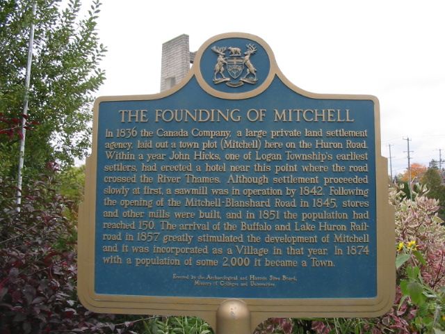
Photo by contributor David Brown - Posted October, 2004
Photo from Google Street View ©2011 Google - Posted January, 2011
Plaque Location
The County of Perth
The Municipality of West Perth
In Mitchell, in a park on the north side of Highway 8 at the west end of the North Thames River bridge
Coordinates: N 43 28.149 W 81 11.971 |
Plaque Text
In 1836 the Canada Company, a large private land settlement agency, laid out a town plot (Mitchell) here on the Huron Road. Within a year John Hicks, one of Logan Township's earliest settlers, had erected a hotel near this point where the road crossed the Thames River. Although settlement proceeded slowly at first, a sawmill was in operation by 1842. Following the opening of the Mitchell-Blanshard Road in 1845 stores and other mills were built and in 1851 the population had reached 150. The arrival of the Buffalo and Lake Huron Railroad in 1857 greatly stimulated the development of Mitchell and it was incorporated as a Village in that year. In 1874 with a population of some 2000 it became a Town.
More
Information
More
Settlements
Here are the visitors' comments for this page.
(none yet)
Here's where you can sent me a comment for this page.
Note: Your email address will be posted at the end of your comment so others can respond to you unless you request otherwise.
Note: Comments are moderated. Yours will appear on this page within 24 hours (usually much sooner).
Note: As soon as I have posted your comment, a reply to your email will be sent informing you.
To send me your comment, click .
Thanks
Alan L Brown
Webmaster
Note: If you wish to send me a personal email, click .