Discover Ontario's history as told through its plaques
2004 - Now in our 15th Year - 2019
To find out all about me, you can visit the Home Page
Looking at this page on a smartphone?
For best viewing, hold your phone
in Landscape mode (Horizontal)
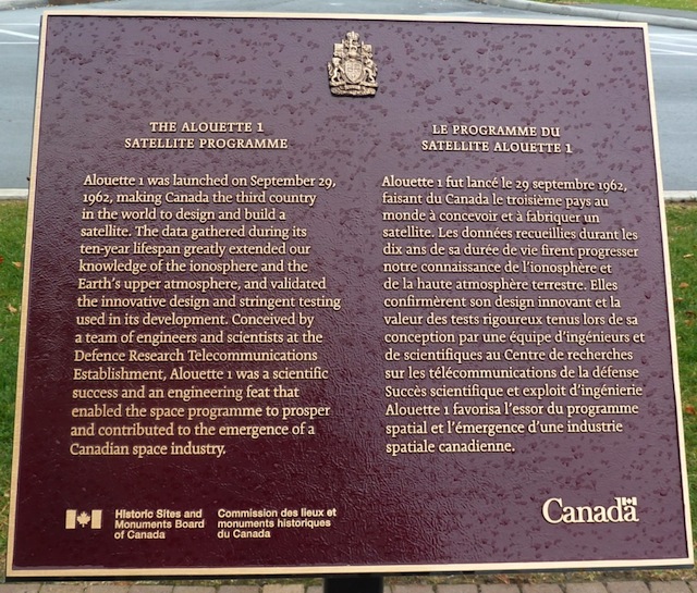
The Alouette 1 Satellite Programme
Photos by contributor Colin Old - Posted December, 2011
Plaque Location
The City of Ottawa
At the entrance to the Government of Canada's
Communications Research Centre on Carling Avenue
1.5 km east of Herzberg Road
Coordinates: N 45 20.697 W 75 52.975 |
Plaque Text
Alouette 1 was launched on September 29, 1962, making Canada the third country in the world to design and build a satellite. The data gathered during its ten-year lifespan greatly extended our knowledge of the ionosphere and the Earth's upper atmosphere, and validated the innovative design and stringent testing used in its development. Conceived by a team of engineers and scientists at the Defence Research Telecommunications Establishment, Alouette 1 was a scientific success and an engineering feat that enabled the space programme to prosper and contributed to the emergence of a Canadian space industry.
More
Information
More
Technology
More
Ottawa Plaques
Here are the visitors' comments for this page.
(none yet)
Here's where you can send me a comment for this page.
Note: Your email address will be posted at the end of your comment so others can respond to you unless you request otherwise.
Note: Comments are moderated. Yours will appear on this page within 24 hours (usually much sooner).
Note: As soon as I have posted your comment, a reply to your email will be sent informing you.
To send me your comment, click .
Thanks
Alan L Brown
Webmaster
Note: If you wish to send me a personal email, click .