Discover Ontario's history as told through its plaques
2004 - Now in our 15th Year - 2019
To find out all about me, you can visit the Home Page
Looking at this page on a smartphone?
For best viewing, hold your phone
in Landscape mode (Horizontal)
Cobourg and Peterborough Railway 1852-1898
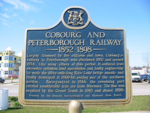
Photo by Alan L Brown - Posted December, 2010
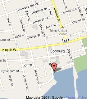
Photo from Google Street View ©2018 Google - Posted April, 2018
Plaque Location
The County of Northumberland
The Town of Cobourg
On the east side of 3 Street, south of Albert Street
where it meets the water
near the north end of the Cobourg Marina
Coordinates: N 43 57.414 W 78 10.033 |
 |
Plaque Text
Largely financed by the citizens and town, Cobourg's railway to Peterborough was chartered 1852 and opened 1854. Like many others of this period, it suffered from excessive optimism, land speculation and faulty engineering. Ice made the 5 km long Rice Lake bridge unsafe and finally destroyed it 1860-61, ending use of the northern section. Reorganized in 1866, the remaining part carried considerable iron ore from Marmara. The line was acquired by the Grand Trunk in 1893 and closed 1898.
Another plaque at this location
The Founding of Cobourg
More
Information
More
Railways
More
Cobourg Plaques
Here are the visitors' comments for this page.
(none yet)
Here's where you can send me a comment for this page.
Note: Your email address will be posted at the end of your comment so others can respond to you unless you request otherwise.
Note: Comments are moderated. Yours will appear on this page within 24 hours (usually much sooner).
Note: As soon as I have posted your comment, a reply to your email will be sent informing you.
To send me your comment, click .
Thanks
Alan L Brown
Webmaster
Note: If you wish to send me a personal email, click .