Discover Ontario's history as told through its plaques
2004 - Now in our 15th Year - 2019
To find out all about me, you can visit the Home Page
Looking at this page on a smartphone?
For best viewing, hold your phone
in Landscape mode (Horizontal)
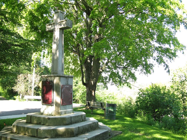
Cliff Site
Photos by contributor Wayne Adam - Posted October, 2010
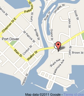
Plaque Location
The County of Norfolk
In Port Dover, on the north side of the west end of
Brown Street, east of the Lynn River, south of Highway 6
Coordinates: N 42 47.140 W 80 11.771 |
 |
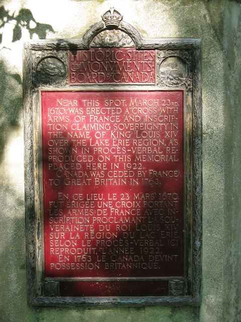
First Plaque Text
Near this spot, March 23rd, 1670, was erected a cross with arms of France and inscription claiming sovereignty in the name of King Louis XIV over the Lake Erie region, as shown in procés-verbal reproduced on this memorial placed here in 1922. Canada was ceded by France to Great Britain in 1763.
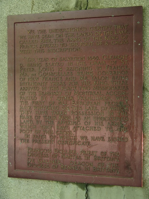
Second Plaque Text
We the undersigned certify that we have seen on the lands of the Lake, called Erie, the arms of the King of France affixed to the foot of a cross with this inscription:
"The year of salvation 1669, Clement 9, being seated in the chair of St. Peter, Louis 14 reigning in France, Mr. de Courcelles being governor of New France and Mr. Talon being intendant there for the King, there arrived in this place two missionaries of the Seminary of Montreal, accompanied by 7 other Frenchmen, who, the first of all European peoples, have wintered on this lake, of which they have taken possession in the name of their King, as an unoccupied land, by the affixing of his arms, which they have attached to the foot of this cross."
In faith of which we have signed the present certificate.
François Dollier, priest of the Diocese of Nantes, in Brittany. De Galinée, deacon of the Diocese of Rennes in Brittany.
Related Ontario plaque
Wintering Site
More
Information
More
Explorers
Here are the visitors' comments for this page.
> Posted October 24, 2010
An etching of this cross graced a Parks Canada handbook listing all the national historical plaques in Ontario. The book was "National Historic Sites--Ontario Region" (1980). I used that as my bible for years of plaque-hunting. It was gratifying to visit this site in the late 80s or early 90s. I hadn't been back since, so I'm delighted to revisit and photograph it for this website. It's a special place, not least because it was the first national historic site to be marked by the Historic Sites and Monuments Board, in 1922. -Wayne
Here's where you can send me a comment for this page.
Note: Your email address will be posted at the end of your comment so others can respond to you unless you request otherwise.
Note: Comments are moderated. Yours will appear on this page within 24 hours (usually much sooner).
Note: As soon as I have posted your comment, a reply to your email will be sent informing you.
To send me your comment, click .
Thanks
Alan L Brown
Webmaster
Note: If you wish to send me a personal email, click .