at ontarioplaques.com
Learn a little Ontario history as told through its plaques
Fort Wellington
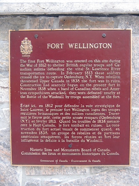
Photo by Rick Mason - Posted September, 2012
Photo by Rick Mason - Posted September, 2012
Photo Source - Wikipedia
Plaque Location
The United Counties of Leeds & Grenville
The Town of Prescott
At the visitor centre at
Fort Wellington National Historic Site
on King Street East (Road 2)
2 blocks east of Edward Street South (Road 18)
Coordinates: N 44 42.783 W 75 30.625 |
Plaque Text
The first Fort Wellington was erected on this site during the War of 1812 to shelter British regular troops and Canadian Militia defending the vital St. Lawrence River transportation route. In February 1813 these soldiers crossed the ice to capture Ogdensburg, N.Y. When rebellion threatened Upper Canada in 1838 the fort was in ruins. Construction had scarcely begun on the present fort in 1838 when a band of Canadian rebels and American sympathizers attacked; they were defeated nearby at the Battle of the Windmill by troops assembled at the fort.
Another plaque at this location
Fort Wellington
Related Ontario plaques
Capture of Ogdensburg
The Battle of the Windmill
More
Information
More
Military
More
Prescott Plaques
Here are the visitors' comments for this page.
(none yet)
Here's where you can write a comment for this page.
Note: If your comment includes a question, it's best to include your email address so others can respond to you.
Note: Comments are moderated. Yours will appear on this page within 24 hours (usually much sooner).
Note: As soon as the comment is posted, a link to it will appear on the home page in the section "Here are the 10 latest plaque pages with a new comment added by a visitor to this site."