Discover Ontario's history as told through its plaques
2004 - Now in our 13th Year - 2017
To see what's new on this site, you can visit the Home Page
Looking at this page on a smartphone?
For best viewing, hold your phone
in Landscape mode (Horizontal)
The Holleford Crater
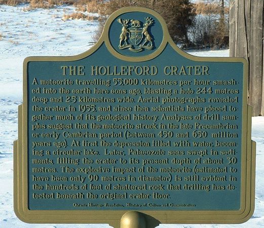
Photo by contributor LeeAnn Beer - Posted July, 2004
Photo from Google Street View ©2017 Google - Posted August, 2017
Plaque Location
The County of Frontenac
The Township of South Frontenac
About 5 km northeast of Hartington, north of Kingston,
on Trousdale Road .3 km west of Holleford Road
Coordinates: N 44 27.353 W 76 37.675 |
Plaque Text
A meteorite travelling 55,000 kilometres per hour smashed into the earth here eons ago, blasting a hole 244 metres deep and 2.5 kilometres wide. Aerial photographs revealed the crater in 1955, and since then scientists have pieced together much of its geological history. Analyses of drill samples suggest that the meteorite struck in the late Precambrian or early Cambrian period (between 450 and 650 million years ago). At first the depression filled with water becoming a circular lake. Later Palaeozoic seas swept in sediments filling the crater to its present depth of about 30 metres. The explosive impact of the meteorite (estimated to have been only 90 metres in diameter) is still evident in the hundreds of metres of shattered rock that drilling has detected beneath the original crater floor.
Related Ontario plaque
The Brent Crater
More
Information
More
Landforms
Here are the visitors' comments for this page.
> Posted August 12, 2017
Hi, just wanted to clarify Jack Babcock or Babcook was raised 2 miles north of the Crater. Jack did go to the old school at the corner of Holleford Rd and New Morin road, near the Crater.
Gail Babcook
> Posted August 7, 2013
We missed the plaque, now that I read the location is near the barn , I will go back. This ties into Desert Lake Road for an excellent motorcycle ride.Regards, Mike J
> Posted October 17, 2011
I am a relative of the owner of the Crater Farm and a distant relative of Jack Babcock. Though Jack did visit the homestead this was not his homestead. It was his uncle's home. Just thought I would put that out there.
> Posted June 18, 2011
Map is showing wrong location - waaaaay wrong. Should be: 44.455962,-76.628737 - LeeAnn Beer [Editor's Response: Thanks. Fixed.]
> Posted February 22, 2010
Hello! "Me again", after our most enjoyable drive to see the crater and plaque last summer; after which I emailed you, and thank you for writing up the clarification of its exact location. Now here is an "off-topic" subject about that farm, which is probably not relevant but I thought I'd let you know. The farm was the childhood home of Jack Babcock, Canada's oldest First World War veteran (b.July 23 1900. d.Feb. 18 2010). (Source: The Globe and Mail: Sat.Feb.20,2010. P.M12).
Sincerely, Dave Welham
> Posted August 22, 2008
I stumbled on this quite by accident this morning out taking early fall color changes. I did not know this existed till now.
Here's where you can sent me a comment for this page.
Note: Your email address will be posted at the end of your comment so others can respond to you unless you request otherwise.
Note: Comments are moderated. Yours will appear on this page within 24 hours (usually much sooner).
Note: As soon as I have posted your comment, a reply to your email will be sent informing you.
To send me your comment, click .
Thanks
Alan L Brown
Webmaster
Note: If you wish to send me a personal email, click .