Discover Ontario's history as told through its plaques
2004 - Now in our 13th Year - 2017
To see what's new on this site, you can visit the Home Page
Looking at this page on a smartphone?
For best viewing, hold your phone
in Landscape mode (Horizontal)
Bois Blanc Island Blockhouses
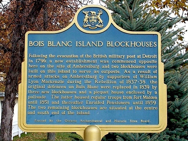
Photo by contributor Bill Jarvis - Posted January, 2007

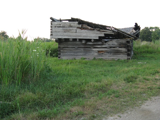
Photo by contributor Wayne Adam - Posted September, 2011
Blockhouse Photo by contributor Wayne Adam - Posted September, 2011
Blockhouse Photo by contributor Julka Vlajic - Posted August, 2016
(Note from Julka Vlajic: This photo was taken on July 8th, 2016 of the reconstructed blockhouse. It has been reconstructed as close as possible to what it looked like in 1839 thanks to the tireless efforts made by Mr. Bill Brundage who is a retired school principal (that's him standing beside the flagpole). He actually has the blockhouse open for tours on Sundays from 1 to 5 pm from May 1st to October 31st.)
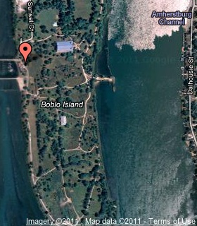
Plaque Location
The County of Essex
The Town of Amherstburg
Plaque is next to a gallery, near a marina and restaurant
on the west-central side of Bois Blanc (Boblo) Island
accessible via the ferry from Elliott's Point
just south of Amherstburg on Road 20
Coordinates: N 42 05.691 W 83 07.376 |
 |
Plaque Text
Following the evacuation of the British military post at Detroit in 1796, a new establishment was commenced opposite here on the site of Amherstburg, and two blockhouses were built on this island to serve as outposts. As a result of armed attacks on Amherstburg by supporters of William Lyon Mackenzie during the Rebellion of 1837-38, the original defences on Bois Blanc were replaced in 1839 by three new blockhouses, and a picquet house enclosed by a palisade. The latter housed regular troops from Fort Malden until 1851 and thereafter Enrolled Pensioners until 1859. The two remaining blockhouses are situated at the centre and south end of the island.
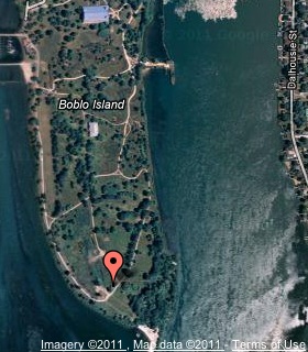
Blockhouse: N 42 05.269 W 83 07.191 |
 |
More
Information
More
Military
Here are the visitors' comments for this page.
> Posted October 21, 2015
Thank you so much for the exciting photos and report on the Bois Blanc Blockhouses. Seeing the volunteer efforts there to restore the blockhouse encourages me to keep stirring up the people of King Township to rescue our 1837 Drill Shed which is desperately in need of TLC!! It is also helpful to be able to see both Bois Blanc and King Township as part of the chain of defense including the Blockhouses in Toronto (Bloor and Yonge) and early Stanley Barracks, to defend jointly against the US and its American sympathizers among the 1837 Rebellion group. Is anyone out there doing a comprehensive study with photos of however many of these structures are extant (or recorded in pictures) to give the public an idea of the scope of these defences of our country? Kudos to the volunteers and to your post on this site.
Kathleen Adamson, Lloydtown (King Twp)
> Posted November 19, 2011
Interestingly, this plaque is not located near either of the two blockhouses. One, said by locals to be a reconstruction, is in the east-middle part of the island. The other is toward the southern end of the island loop trail, and this is the blockhouse pictured above, in a state of ruin in 2011. This historic blockhouse is part of Bois Blanc Island Lighthouse and Blockhouse National Historic Site, a unit of the national park system, administered by Parks Canada. It is officially listed as "closed", but visitors can make the trek to see both the lighthouse (built 1837) and the blockhouse (1838).
A report this month (Nov. 2011) says the blockhouse is being disassembled by volunteers, will be stored for the winter in a warehouse, then reassembled and restored in time for War of 1812 Bicentennial celebrations in June 2012. I'm fortunate to have photographed the building in its neglected state.
The island is accessible via ferry. Round trip is $10 per person in a vehicle, $20 for a family. Pedestrian rates are offered. The car price seemed steep, given it's a five minute crossing, and because a car is of limited help in getting to the national historic site. Cars are not permitted south of the restaurant-marina, where the plaque is located, and it takes about 20 minutes to hike from there to the lighthouse and blockhouse. You can always try hailing a golf cart! Several residents use them to get around the island.
If you can, plan on a half- or full-day trip to enjoy these sites, plus the beach, wildlife, trails, and the huge Dance Pavilion designed by Albert Kahn, said to be the world's second largest, with a capacity of 5,000. A maritime monument dates to 1909. Little evidence remains of the hugely popular Bob-Lo Island Amusement Park that once dominated the island for nearly 100 years. Opening in 1898, Bob-Lo entertained generations who arrived by steamer from Detroit and Windsor. It closed in 1993, and its rides were sold the following year. The 265-foot Sky Tower remains a ghostly reminder of happy days. The north end of the island has been developed into a luxury housing subdivision. -Wayne
Here's where you can sent me a comment for this page.
Note: Your email address will be posted at the end of your comment so others can respond to you unless you request otherwise.
Note: Comments are moderated. Yours will appear on this page within 24 hours (usually much sooner).
Note: As soon as I have posted your comment, a reply to your email will be sent informing you.
To send me your comment, click .
Thanks
Alan L Brown
Webmaster
Note: If you wish to send me a personal email, click .