Discover Ontario's history as told through its plaques
2004 - Now in our 14th Year - 2018
To see what's new on this site, you can visit the Home Page
Looking at this page on a smartphone?
For best viewing, hold your phone
in Landscape mode (Horizontal)
The Development of Pelee Island
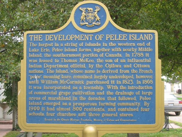
Photo by Alan L Brown - Posted September, 2004
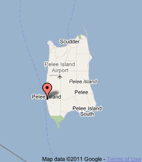
Plaque Location
The County of Essex
The Township of Pelee
One Pelee Island, in front of a museum
across from the West Dock
Coordinates: N 41 45.362 W 82 41.277 |
 |
Plaque Text
The largest in a string of islands in the western end of Lake Erie, Pelee Island forms, together with nearby Middle Island, the southernmost portion of Canada. In 1788 it was leased to Thomas McKee, the son of an influential Indian Department official, by the Ojibwa and Ottawa nations. The island, whose name is derived from the French "pelée", meaning bare, remained largely undeveloped, however, until William McCormick purchased it in 1823. In 1868 it was incorporated as a township. With the introduction of commercial grape cultivation and the drainage of large hectares of marshland in the decades that followed, Pelee Island emerged as a prosperous farming community. By 1900 it had almost 800 residents, and contained four schools, four churches and three general stores.
More
Information
More
Settlements
More
Pelee Plaques
Here are the visitors' comments for this page.
(none yet)
Here's where you can send me a comment for this page.
Note: Your email address will be posted at the end of your comment so others can respond to you unless you request otherwise.
Note: Comments are moderated. Yours will appear on this page within 24 hours (usually much sooner).
Note: As soon as I have posted your comment, a reply to your email will be sent informing you.
To send me your comment, click .
Thanks
Alan L Brown
Webmaster
Note: If you wish to send me a personal email, click .