Discover Ontario's history as told through its plaques
2004 - Now in our 14th Year - 2018
To see what's new on this site, you can visit the Home Page
Looking at this page on a smartphone?
For best viewing, hold your phone
in Landscape mode (Horizontal)
The Founding of Cochrane
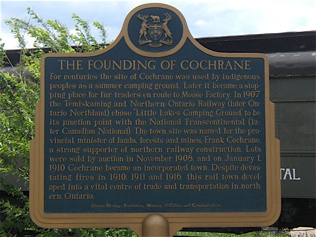
Photo by contributors Ronald Kirkbride and Murray Wilson - Posted June, 2006
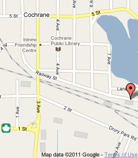
Plaque Location
The District of Cochrane
The Town of Cochrane
In Cochrane, on Railway Street east of 7th Avenue
Coordinates: N 49 03.623 W 81 01.306 |
 |
Plaque Text
For centuries the site of Cochrane was used by indigenous peoples as a summer camping ground. Later it became a stopping place for fur traders en route to Moose Factory. In 1907 the Temiskaming and Northern Ontario Railway (later Ontario Northland) chose 'Little Lakes Camping Ground' to be its junction point with the National Transcontinental (later Canadian National). The town site was named for the provincial minister of lands, forests and mines, Frank Cochrane, a strong supporter of northern railway construction. Lots were sold by auction in November 1908, and on January 1, 1910 Cochrane became an incorporated town. Despite devastating fires in 1910, 1911 and 1916, this rail town developed into a vital centre of trade and transportation in northern Ontario.
More
Information
More
Settlements
More
Fur Trade
More
Cochrane Plaques
Here are the visitors' comments for this page.
(none yet)
Here's where you can send me a comment for this page.
Note: Your email address will be posted at the end of your comment so others can respond to you unless you request otherwise.
Note: Comments are moderated. Yours will appear on this page within 24 hours (usually much sooner).
Note: As soon as I have posted your comment, a reply to your email will be sent informing you.
To send me your comment, click .
Thanks
Alan L Brown
Webmaster
Note: If you wish to send me a personal email, click .