Discover Ontario's history as told through its plaques
2004 - Now in our 15th Year - 2019
To find out all about me, you can visit the Home Page
Looking at this page on a smartphone?
For best viewing, hold your phone
in Landscape mode (Horizontal)
Wallaceburg
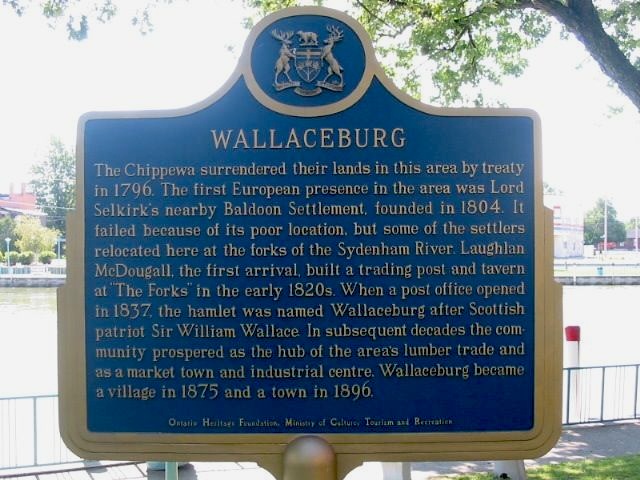
Photo by Alan L Brown - Posted August, 2004
Plaque Location
The Municipality of Chatham-Kent
In Wallaceburg, at the water's edge
in a park at the north end of
the Highway 40 bridge over the North Sydenham River
Coordinates: N 42 35.533 W 82 23.279 |
Plaque Text
The Chippewa surrendered their lands in this area by treaty in 1796. The first European presence in this area was Lord Selkirk's nearby Baldoon Settlement, founded in 1804. It failed because of its poor location, but some of the settlers relocated here at the forks of the Sydenham River. Laughlan McDougall, the first arrival, built a trading post and tavern at "The Forks" in the early 1820s. When a post office opened in 1837, the hamlet was named Wallaceburg after Scottish patriot Sir William Wallace. In subsequent decades the community prospered as the hub of the area's lumber trade and as a market town and industrial centre. Wallaceburg became a village in 1875 and a town in 1896.
More
Information
More
Settlements
Other Plaques in Wallaceburg
James Paris Lee 1831-1904
Here are the visitors' comments for this page.
(none yet)
Here's where you can send me a comment for this page.
Note: Your email address will be posted at the end of your comment so others can respond to you unless you request otherwise.
Note: Comments are moderated. Yours will appear on this page within 24 hours (usually much sooner).
Note: As soon as I have posted your comment, a reply to your email will be sent informing you.
To send me your comment, click .
Thanks
Alan L Brown
Webmaster
Note: If you wish to send me a personal email, click .