Here's where you can learn a little Ontario history
The Founding of Killarney
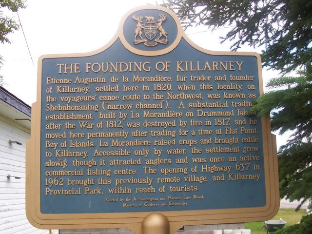
Photo by contributor Wayne Cook - July, 2005
Plaque Location
The District of Sudbury
The Municipality of Killarney
On the corner of Commissioner Street and
St. Charles Street (Highway 637)
Coordinates: N 45 58.290 W 81 30.692 |
 |
Plaque Text
Etienne Augustin de la Morandière, fur trader and founder of Killarney, settled here in 1820, when this locality, on the voyageurs' canoe route to the Northwest, was known as Shebahonaning ("narrow channel"). A substantial trading establishment, built by La Morandière on Drummond Island after the War of 1812, was destroyed by fire in 1817, and he moved here permanently after trading for a time at Flat Point, Bay of Islands. La Morandière raised crops and brought cattle to Killarney. Accessible only by water, the settlement grew slowly, though it attracted anglers and was once an active commercial fishing centre. The opening of Highway 637 in 1962 brought this previously remote village and Killarney Provincial Park, within reach of tourists.
More
Information
More
Settlements
Here are the comments for this page.
(none yet)
Here's where you can write a comment for this page.
Note: If you wish to ask me a question, please use the email link in the menu.
Note: Comments are moderated. Yours will appear on this page within 24 hours
(usually much sooner).