Discover Ontario's history as told through its plaques
2004 - Now in our 13th Year - 2017
To see what's new on this site, you can visit the Home Page
Looking at this page on a smartphone?
For best viewing, hold your phone
in Landscape mode (Horizontal)
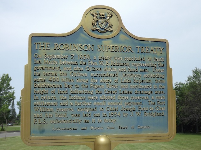
The Robinson Superior Treaty
Photos by contributors Peter and Gloria - Posted July, 2012
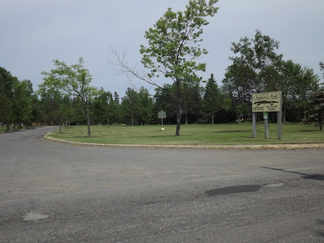
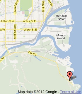
Plaque Location
The District of Thunder Bay
The City of Thunder Bay
On the road to Chippawa Park, 6.4 km east and south of
James Street South on the Fort William First Nation
just south of Thunder Bay, 9.7 km from Highway 61
Coordinates: N 48 20.059 W 89 12.884 |
 |
Plaque Text
On September 7, 1850, a treaty was concluded at Sault Ste. Marie between the Hon. W.B. Robinson, representing the government, and nine Ojibwa chiefs and head men. Under its terms the Ojibwa surrendered territory extending some 640 km along the shore of Lake Superior, from Batchawana Bay to the Pigeon River, and northward to the height of land delimiting the Great Lakes drainage area. In return, the Indians were allotted three reserves, a cash settlement and a further small annual payment. The Fort William reserve, assigned to Chief Joseph Peau de Chat and his band, was laid out in 1854 by J.W. Bridgland, P.L.S., substantially as it is today.
Related Ontario plaque
Manitoulin Treaties 1836 and 1862
More
Information
More
First Nations
Here are the visitors' comments for this page.
> Posted October 10, 2012
In reality First Nations are no better stewards of the land than any one else. Currently two first Nations, Michipicoten and Batchewana, are clashing over whose "territorial rights" are most valid within the Robinson Superior Treaty lands. The fight is over who gets money from wind power. The lands along the coast of Lake Superior will be scarred by wind turbines developed by a Calgary company called Blue Earth Renewables while one or both of these bands will trade "Mother Earth" for cash.
> Posted August 22, 2012
There is nothing honourable about a person who leads our people into signing away land that didn't belong to them. 2000 GBP Great Britain Pounds was offered to the signatories on that fateful day in Sault Ste. Marie by the supposedly Honourable W.B. Robinson. 2000 pounds in British currency converts to $3110.30 at the current exchange rate for today. There was also an annuity of 500 pounds that was given which today translates to $777.60 and each person was allowed 1 pound which is $1.56. Another matter relating to that is the surveying of the lands set aside as reserves. The reserve areas were supposed to be surveyed using the leagues measurement. A league equals 3.45 miles. The reserve lands were surveyed using the miles measurement which is way smaller than the league. An article in the Anishinabek News (July-August 2012) by David Shanahan brings this to light. When one takes into consideration what a vast area is designated in the Robinson Superior Treaty, it is disheartening to see that Anishinabe got gypped.
> Posted June 5, 2010
The traditional first nations people of this country are its only hope. Please help mother earth. Please remember your ancestry and teach the "whites" how to live in harmony with the earth and how not to destroy her. She needs your help.
Tara Outhouse
(Irish, Dutch, English, Scottish ancestry but a true Indian in my heart)
Here's where you can sent me a comment for this page.
Note: Your email address will be posted at the end of your comment so others can respond to you unless you request otherwise.
Note: Comments are moderated. Yours will appear on this page within 24 hours (usually much sooner).
Note: As soon as I have posted your comment, a reply to your email will be sent informing you.
To send me your comment, click .
Thanks
Alan L Brown
Webmaster
Note: If you wish to send me a personal email, click .