Discover Ontario's history as told through its plaques
2004 - Now in our 12th Year - 2016
To see what's new on this site, you can visit the Home Page
Looking at this page on a smartphone?
For best viewing, hold your phone
in Landscape mode (Horizontal)
The Brockville, Westport & Sault Ste. Marie Railway
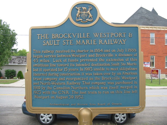
Photo by contributor Anonymous July 8, 2007
Photo from Google Street View ©2010 Google - Posted December, 2010
Plaque Location
The United Counties of Leeds & Grenville
The Village of Westport
On Concession Street (Road 42), west side
just north of Rideau Street (Road 10)
Coordinates: N 44 40.510 W 76 23.930 |
Plaque Text
This railway received its charter in 1884, and on July 1, 1888, began service between Westport and Brockville, a distance of 73 km. Lack of funds prevented the extension of this ambitious line toward its intended destination, Sault Ste. Marie, but it operated for 15 years. In 1903, unable to meet obligations incurred during construction, it was taken over by an American trust company and reorganized as the Brockville, Westport and northwestern Railway. That company was purchased in 1910 by the Canadian Northern which was itself merged in 1923 with the C.N.R. The last train to run on this line left Westport on August 30, 1952.
More
Railways
More
Westport Plaques
Here are the visitors' comments for this page.
(none yet)
Here's where you can sent me a comment for this page.
Note: Your email address will be posted at the end of your comment so others can respond to you unless you request otherwise.
Note: Comments are moderated. Yours will appear on this page within 24 hours (usually much sooner).
Note: As soon as I have posted your comment, a reply to your email will be sent informing you.
To send me your comment, click .
Thanks
Alan L Brown
Webmaster
Note: If you wish to send me a personal email, click .