Discover Ontario's history as told through its plaques
2004 - Now in our 12th Year - 2016
To see what's new on this site, you can visit the Home Page
Looking at this page on a smartphone?
For best viewing, hold your phone
in Landscape mode (Horizontal)
The St. Clair Tunnel
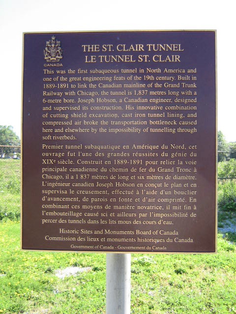
Photo by Alan L Brown - Posted June, 2009
Photo from Google Street View ©2010 Google - Posted December, 2010
Photo Source - Wikimedia Commons
Plaque Location
The County of Lambton
The City of Sarnia
On the north side of St. Andrew Street
between Christina Street South and Vidal Street South
Coordinates: N 42 57.461 W 82 24.614 |
Plaque Text
This was the first subaqueous tunnel in North America and one of the great engineering feats of the 19th century. Built in 1889-1891 to link the Canadian mainline of the Grand Trunk Railway with Chicago, the tunnel is 1,837 metres long with a 6-metre bore. Joseph Hobson, a Canadian engineer, designed and supervised its construction. His innovative combination of cutting shield excavation, cast iron tunnel lining, and compressed air broke the transportation bottleneck caused here and elsewhere by the impossibility of tunnelling through soft riverbeds.
Another plaque at this location
The St. Clair Tunnel
More
Information
More
Railways
More
Sarnia Plaques
Here are the visitors' comments for this page.
(none yet)
Here's where you can sent me a comment for this page.
Note: Your email address will be posted at the end of your comment so others can respond to you unless you request otherwise.
Note: Comments are moderated. Yours will appear on this page within 24 hours (usually much sooner).
Note: As soon as I have posted your comment, a reply to your email will be sent informing you.
To send me your comment, click .
Thanks
Alan L Brown
Webmaster
Note: If you wish to send me a personal email, click .